América II, Tamaulipas facts for kids
Quick facts for kids
América
|
||
|---|---|---|
|
||
 |
||
| Country | Mexico | |
| State | Tamaulipas | |
| Municipality | Nuevo Laredo | |
| Elevation | 135 m (443 ft) | |
| Population
(2010)
|
||
| • Total | 197 | |
| Time zone | UTC-6 (CST) | |
| • Summer (DST) | UTC-5 (CST) | |
| Codigo Postal |
88000
|
|
| Area code(s) | +52-867 | |
| Nearest Airports: Laredo: Laredo International Airport KLRD LRD Nuevo Laredo: Quetzalcoatl International Airport MMNL NLD | ||
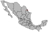
América is a small community located in the Nuevo Laredo Municipality in the Mexican state of Tamaulipas. It's a place where about 197 people live, according to a count done in 2010. The community is located 135 meters (about 443 feet) above sea level. There's another place with the same name, América, nearby. This other América is just to the west, across Mexican Federal Highway 85.
See also
 In Spanish: América II para niños
Black History Month on Kiddle
Contemporary African-American Artists:
 | Janet Taylor Pickett |
 | Synthia Saint James |
 | Howardena Pindell |
 | Faith Ringgold |

All content from Kiddle encyclopedia articles (including the article images and facts) can be freely used under Attribution-ShareAlike license, unless stated otherwise. Cite this article:
América II, Tamaulipas Facts for Kids. Kiddle Encyclopedia.

