Atterberry No. 10 Precinct, Menard County, Illinois facts for kids
Quick facts for kids
Atterberry No. 10 Precinct
|
|
|---|---|

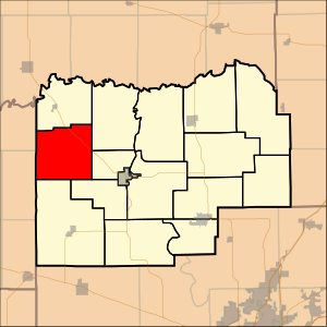
Location in Menard County
|
|
| Country | United States |
| State | Illinois |
| County | Menard |
| Area | |
| • Total | 21.92 sq mi (56.77 km2) |
| • Land | 21.92 sq mi (56.77 km2) |
| • Water | 0 sq mi (0 km2) 0% |
| Elevation | 600 ft (183 m) |
| Population
(2000)
|
|
| • Total | 194 |
| • Density | 8.9/sq mi (3.4/km2) |
| GNIS feature ID | 1928440 |
Atterberry No. 10 Precinct is a small area located in Menard County, Illinois. It is part of the United States. In the year 2000, about 194 people lived there.
What is Atterberry No. 10 Precinct?
Atterberry No. 10 Precinct is a specific geographic area. It is used for things like voting and local government. Think of it like a neighborhood or a small district.
Where is Atterberry Precinct Located?
This precinct is found in Menard County, Illinois. Illinois is a state in the central part of the United States. Menard County is known for its history and farming areas.
Location in Illinois
Illinois is a large state with many different types of places. Atterberry No. 10 Precinct is in a more rural part of Menard County. It is not a big city.
Part of Menard County
Menard County is home to several small towns and rural areas. Atterberry No. 10 Precinct is one of these areas. It helps organize local services.
How Many People Live Here?
According to the 2000 census, 194 people called Atterberry No. 10 Precinct home. This makes it a very small community.
Population Details
The population density was about 3.4 people per square kilometer. This means there is a lot of open space. It is not a crowded place.
Area Size
The total area of the precinct is about 56.77 square kilometers. This is roughly 21.92 square miles. All of this area is land, with no water.
What is a Precinct?
A precinct is a small voting district. It is a specific area where people go to vote. It helps manage elections.
Role in Elections
Each precinct has a polling place. This is where citizens cast their votes. It makes sure everyone can vote easily.
Local Government
Precincts also help organize local government. They are used to divide up larger areas. This makes it easier to manage public services.
Geography of Atterberry Precinct
Atterberry No. 10 Precinct is mostly flat land. It is typical of the Illinois landscape. The elevation is about 183 meters (600 feet) above sea level.
Land Features
The land here is suitable for farming. Many areas in Illinois are used for agriculture. This precinct is no exception.
Climate and Environment
The climate in Illinois includes warm summers and cold winters. This area experiences all four seasons. The environment is mainly rural.
See also
 In Spanish: Distrito electoral de Atterberry n.º 10 para niños

