
Caer Lêb facts for kids

Caer Lêb, the central enclosure
|
|
| Location | Anglesey, Wales |
|---|---|
| Region | Great Britain |
| Coordinates | 53°10′54″N 4°17′12″W / 53.1818°N 4.2868°W |
| Type | enclosure |
| Length | 80m |
| Width | 72m |
| Height | 1m |
| History | |
| Material | earth |
| Periods | Roman and mediaeval |
| Site notes | |
| Management | Cadw |
| Public access | Yes |
Caer Lêb is an ancient site on Anglesey, an island in Wales. It's a special place that shows us how people lived long ago. This site was used during the time of the Roman Empire and later in the Middle Ages. Its name means "Leaven Castle." Caer Lêb is low to the ground, near a river called Afon Braint. It has two rows of earth banks and ditches that form a pentagon shape. Some parts of these banks are now flat. The original way to enter the site was from the east. Other gaps you see today were made by animals.
Contents
Discovering Caer Lêb
Caer Lêb is a fascinating historical site in Wales. It was used by people during the Roman Empire and later in the Middle Ages. The site is low to the ground, close to the Afon Braint river. It has two sets of banks made of earth and ditches. These banks form a shape like a five-sided pentagon. Some parts of these banks are now flat. The main way to enter the site was from the east. Other openings you see today were made by animals.
What Was Found at Caer Lêb?
Archaeologists dug at Caer Lêb in 1865. They found signs of buildings inside the main area. There were rectangular buildings on the east side. They also found a round building on the south side. You cannot see these buildings on the ground today.
During the dig, they found pieces of pottery. These pottery pieces showed that people lived here from the 2nd century to the 4th century. This was during the Roman period. On the north side, they found a layer of periwinkle shells. Under a layer of peat, they also found a coin from the Middle Ages. This tells us people used the site for a long time.
Exploring the Area Around Caer Lêb
If you want to visit Caer Lêb, there is a small parking area. It can fit about 4 or 5 cars by the road. A footpath starts from Caer Lêb and goes southwest. This path is on a low ridge, about 2 meters above the Afon Braint river.
You can follow this path over stiles. It passes the old site of a stone circle called Tre'r Dryw Bach. This is about 800 meters away. The path then continues to Castell Bryn Gwyn. From there, it goes on to the Bryn Gwyn stones and the A4080 road.
About 500 meters northwest along the road, near Pont Sarn Las (Green Causeway Bridge), you might see something interesting. If the summer has been very dry, you might see the foundations of three round houses. In the 1800s, people recorded a large settlement here. However, it was destroyed in the 1870s when the land was changed for farming.
Gallery
-
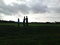
Caer Lêb, view from outer rampart
-
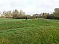
Caer Lêb from the south-western rampart
-
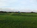
Caer Lêb from outer rampart


