
California Historical Landmarks in Placer County facts for kids
Placer County, California, is a place full of amazing history! It's home to many special spots called California Historical Landmarks. These landmarks are officially recognized places, buildings, or districts that have played an important part in California's past. They help us remember and learn about the exciting events and people who shaped the state.
Placer County is located in the Sierra Nevada foothills. It was a very important area during the California Gold Rush. Many of these landmarks tell stories about mining, early settlements, and the building of the first transcontinental railroad. Exploring them is like taking a trip back in time!
Contents
- What are California Historical Landmarks?
- Famous Places in Placer County
- Auburn
- Dutch Flat
- Emigrant Gap
- Foresthill
- Gold Run
- Griffith Quarry
- Iowa Hill
- Lake Tahoe Outlet Gates
- Michigan Bluff
- Ophir
- Overland Emigrant Trail
- Pioneer Express Trail
- Pioneer Ski Area of America
- Transcontinental Railroad - Auburn
- Transcontinental Railroad - Colfax
- Transcontinental Railroad - Newcastle
- Transcontinental Railroad - Rocklin
- Transcontinental Railroad - Roseville
- Virginiatown
- Yankee Jims
- Images for kids
What are California Historical Landmarks?
California Historical Landmarks are special places. They are chosen because they have a big historical meaning. These landmarks can be old buildings, natural sites, or even entire towns. Each one has a story to tell about California's journey.
When a place becomes a landmark, it gets a special plaque. This plaque explains why the site is important. It helps people learn about the history of the area. These landmarks are protected so future generations can also enjoy them.
Famous Places in Placer County
Placer County has many interesting landmarks. They show different parts of its history. From old mining towns to important trails, each site offers a glimpse into the past.
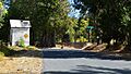
Auburn

Auburn is a historic district in Placer County. It was a key town during the Gold Rush. Many old buildings still stand here. They show what life was like long ago. Auburn also played a role in the building of the Transcontinental Railroad.
Dutch Flat

Dutch Flat is another historic district. It was a busy mining town in the 1850s. Gold miners came here hoping to strike it rich. The town still keeps its old-time charm.
Emigrant Gap

Emigrant Gap is a significant spot. It marks a challenging part of the journey for pioneers. These brave people traveled west on the Emigrant Trail. This area was a tough climb over the Sierra Nevada mountains.
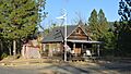
Foresthill

Foresthill is a historic district. It was once a booming gold mining town. It grew quickly during the Gold Rush. The town is located high in the mountains. It offers a look into early mining life.
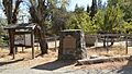
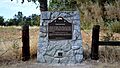
Gold Run

Gold Run is a historic district. It was famous for hydraulic mining. This method used powerful water jets to wash away hillsides. It was a very effective way to find gold.
Griffith Quarry

Griffith Quarry is near Penryn. It was an important granite quarry. Granite from here was used in many famous buildings. It helped build California's cities.
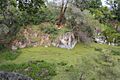
Iowa Hill

Iowa Hill is a historic district. It was a remote and rich gold mining camp. It was hard to reach, but many miners settled there. The town shows the challenges of early mining.
Lake Tahoe Outlet Gates

These gates are in Tahoe City. They control the water flow from Lake Tahoe. This system helps manage water for farming and cities. It's an important part of California's water history.
Michigan Bluff

Michigan Bluff is a historic district. It was another busy gold mining town. It's nestled in the mountains. The town's history is tied to the search for gold.
Ophir
.jpg)
Ophir is a historic district. It was known for its quartz mining. This type of mining involved digging deep underground. Miners extracted gold from rock veins.
Overland Emigrant Trail
This landmark marks a part of the historic Overland Emigrant Trail. Many pioneers traveled this route. They were heading to California during the Gold Rush. It was a long and difficult journey.
Pioneer Express Trail
This trail is part of the Folsom Lake State Recreation Area. It follows an old route. This route was used by early express riders. They delivered mail and goods in the Gold Rush era.
Pioneer Ski Area of America

This landmark is in Squaw Valley. It recognizes the early history of skiing in America. Squaw Valley is famous for its winter sports. It even hosted the Winter Olympics in 1960.
Transcontinental Railroad - Auburn
,_historical_depot_building.jpg)
This site in Auburn marks a key part of the First Transcontinental Railroad. This railroad connected the East and West coasts. It was a huge engineering feat. The building now serves as a Chamber of Commerce.
Transcontinental Railroad - Colfax

Colfax also has a landmark for the Transcontinental Railroad. The railroad brought many changes to California. It made travel and trade much faster.
Transcontinental Railroad - Newcastle
.jpg)
Newcastle was another important stop on the railroad. These landmarks show the path of this historic railway. It helped California grow and connect with the rest of the country.
Transcontinental Railroad - Rocklin
.jpg)
Rocklin also played a role in the railroad's history. The construction of the railroad was a massive undertaking. It involved thousands of workers.
Transcontinental Railroad - Roseville
.jpg)
Roseville is another city with a Transcontinental Railroad landmark. These sites remind us of this incredible achievement. It changed America forever.
Virginiatown

Virginiatown is a historic site near Newcastle. It was an early mining settlement. It shows how towns sprang up quickly during the Gold Rush.
Yankee Jims

Yankee Jims is a historic district near Foresthill. It was a rich gold mining camp. Its remote location made it a unique place. It's another example of a Gold Rush boomtown.
Images for kids
-
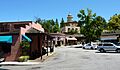
Old Town Auburn, a historic district.
-
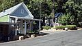
The historic district of Dutch Flat.
-
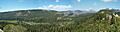
The Emigrant Gap vista point.
-
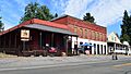
The historic IOOF building in Foresthill.
-
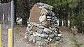
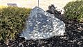
The California Historical Landmark plaque for Gold Run.
-
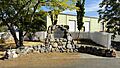
The historic Griffith Quarry in Penryn.
-
A view of the historic district in Iowa Hill.
-
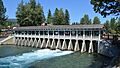
The outlet gates of Lake Tahoe in Tahoe City.
-
The historic district of Michigan Bluff.
-
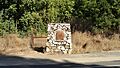
The California Historical Landmark plaque for Ophir.
-
The plaque for the Pioneer Ski Area of America in Squaw Valley.
-
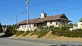
The historic depot building in Auburn, part of the Transcontinental Railroad landmark.
-
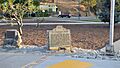
The Transcontinental Railroad marker in Colfax.
-
The Transcontinental Railroad marker in Newcastle.
-
The Transcontinental Railroad marker in Rocklin.
-
The Transcontinental Railroad marker in Roseville.
-
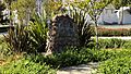
The plaque for Virginiatown.
-
The historic district of Yankee Jims.
