
Colón, El Salvador facts for kids
Quick facts for kids
Colón, La Libertad
|
|
|---|---|

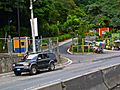
The entrance to Colón via the Pan-American Highway
|
|

Colón, La Libertad
Location in El Salvador
|
|
| Country | |
| Department | La Libertad |
| Area | |
| • Total | 32.45 sq mi (84.05 km2) |
| Elevation | 1,870 ft (570 m) |
| Population | |
| • Total | 96,989 |
| Time zone | UTC-6 (CST) |
Colón is a busy municipality (like a city or town area) located in the La Libertad department of El Salvador. It shares its borders with several other places, including Santa Tecla, Quezaltepeque, San Juan Opico, Ciudad Arce, Sacacoyo, and Talnique.
This area was once known as El Guarumal. It officially became a town on August 20, 1886. Later, on July 24, 1986, it was given the higher status of a villa, which is a type of small city.
Exploring Colón: What are Cantons?
Colón is divided into smaller areas called cantons. Think of them like neighborhoods or smaller districts within the municipality. These cantons help organize the different parts of Colón.
There are twelve cantons that make up Colón:
- Botoncillal
- Cobanal
- Cuyagualo
- El Capulín
- El Limón
- El Manguito
- Entre Ríos
- Hacienda Nueva
- Las Angosturas
- Las Brisas
- Las Moras
- Lourdes
Gallery
-
Entrance to Los Chorros
-
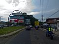
The Canton of Lourdes


See also
 In Spanish: Colón (El Salvador) para niños
