
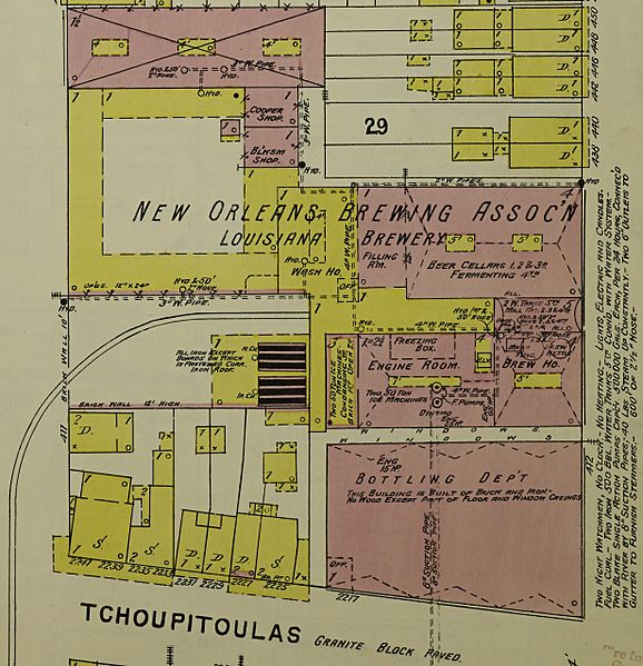
Image: "New Orleans Brewing Association" Brewery in 1896, Sanborn Fire Insurance Map from New Orleans, Orleans Parish, Louisiana. LOC sanborn03376 007-3 (cropped)

Size of this preview: 578 × 599 pixels. Other resolutions: 231 × 240 pixels | 2,462 × 2,553 pixels.
Original image (2,462 × 2,553 pixels, file size: 774 KB, MIME type: image/jpeg)
Description: 1896; Vol. 3. 110 Sheet(s). Bound.
Title: "New Orleans Brewing Association" Brewery in 1896, Sanborn Fire Insurance Map from New Orleans, Orleans Parish, Louisiana. LOC sanborn03376 007-3 (cropped)
Credit: https://www.loc.gov/item/sanborn03376_007/
Author: Unknown authorUnknown author
Permission: This map is available from the United States Library of Congress's Geography & Map Division under the digital ID g4014nm.g03376189603. This tag does not indicate the copyright status of the attached work. A normal copyright tag is still required. See Commons:Licensing for more information.
Usage Terms: Public domain
License: Public domain
Attribution Required?: No
Image usage
The following page links to this image:

All content from Kiddle encyclopedia articles (including the article images and facts) can be freely used under Attribution-ShareAlike license, unless stated otherwise.