
Image: “Top Surface” tracksite (SGDS.18)
Size of this preview: 306 × 599 pixels. Other resolutions: 122 × 240 pixels | 1,967 × 3,853 pixels.
Original image (1,967 × 3,853 pixels, file size: 942 KB, MIME type: image/png)
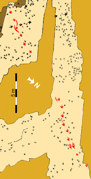
Description: Schematic map of the “Top Surface” tracksite (SGDS.18).
Beige shaded areas represent the “Top Surface” of the Main Track-bearing Sandstone Bed; gold shaded areas are unexcavated; brown areas represent areas removed after mapping to examine lower horizons. The Eubrontes trackway that includes the crouching trace is highlighted in red.
Author: Andrew R. C. Milner, Jerald D. Harris, Martin G. Lockley, James I. Kirkland, Neffra A. Matthews
Usage Terms: Creative Commons Attribution-Share Alike 3.0
License: CC-BY-SA-3.0
License Link: http://creativecommons.org/licenses/by-sa/3.0/
Attribution Required?: Yes
Image usage
The following page links to this image:

All content from Kiddle encyclopedia articles (including the article images and facts) can be freely used under Attribution-ShareAlike license, unless stated otherwise.
.png)