
Image: 1700 CE world map

Size of this preview: 800 × 397 pixels. Other resolutions: 320 × 159 pixels | 4,500 × 2,234 pixels.
Original image (4,500 × 2,234 pixels, file size: 380 KB, MIME type: image/png)
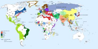
Description: 1700 AD: An illustrative map of the world in the early colonial period. The Mughal Empire in India is at its greatest territorial extent.
Title: 1700 CE world map
Credit: Own work. Blank map from File:World_Map_Blank.svg.
Author: Urnanabha
Usage Terms: Creative Commons Attribution-Share Alike 3.0
License: CC BY-SA 3.0
License Link: https://creativecommons.org/licenses/by-sa/3.0
Attribution Required?: Yes
Image usage
The following 2 pages link to this image:

All content from Kiddle encyclopedia articles (including the article images and facts) can be freely used under Attribution-ShareAlike license, unless stated otherwise.