
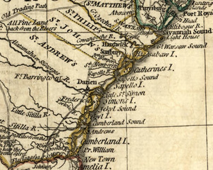
Image: 1776 map of coastal Georgia

Size of this JPG preview of this TIF file: 755 × 600 pixels. Other resolution: 302 × 240 pixels.
Original image (988 × 785 pixels, file size: 1.59 MB, MIME type: image/tiff)
Description: Crop of map with the following description: Scale ca. 1:3,000,000. Relief shown pictorially. "The seat of war, in the southern British colonies, comprehending North and South Carolina, Georgia, East and West Florida, &ca." Hand colored. Insets: Plan of Charlestown [ca. 1:24,000]--Plan of St. Augustine [ca. 1:15,840] LC Maps of North America, 1750-1789, 1396 Available also through the Library of Congress Web site as a raster image. Vault AACR2
Title: 1776 map of coastal Georgia
Credit: https://www.loc.gov/item/gm71005467/
Author: Romans, Bernard; De Brahm, John Gerar William; Robert Sayer And John Bennett (Firm)
Usage Terms: Public domain
License: Public domain
Attribution Required?: No
Image usage
The following page links to this image:

All content from Kiddle encyclopedia articles (including the article images and facts) can be freely used under Attribution-ShareAlike license, unless stated otherwise.