
Image: 1813 Thomson Map of Africa - Geographicus - Africa-thomson-1813

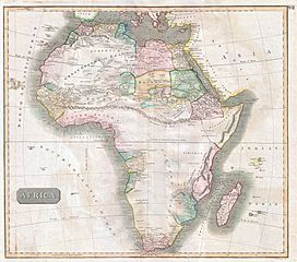
Description: This hand colored map is a steel plate engraving, dating to 1813 by the important English mapmaker John Thomson. It is an early and historically important representation of the continent of Africa. Much of the continent is simply labeled “unknown parts”. Those sections that are known are surprisingly detailed. Caravan routes, temples, and even the distances between Oases are generally noted. Across the center of the continent Thomson details the mythical mountain range known as the “Mountains of the Moon”. The mountains of the moon were first postulated by Ptolemy to be the source of the Nile. This mysterious range remained on maps until the mid 19th century explorations of Burton, Speke, and Livingstone. Today it is generally agreed that references to the Mountains of the Moon refer to the Ruwenzori Range of Kenya & Uganda. This mountain range remains one of the most remote and exotic places on Earth, and is the home of a diversity of bizarre plant and animal life. However, it is not, as postulated, the source of the Nile which lies just to the south in Lake Victoria. Neither Lake Victoria nor Lake Tanganyika, which appear in much earlier Bleau maps, appear on this map. Thomson maps are known for their stunning color, awe inspiring size, and magnificent detail. Thomson’s work, including this map, represents some of the finest cartographic art of the 19th century.
Usage Terms: Public domain
Image usage
The following page links to this image:
