
Image: 1833 Chicago map by Conley & Stelzer

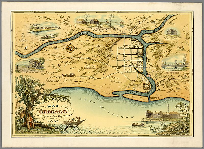
Description: 1933 pictorial map of Chicago issued by Walter Conley and O. E. Stelzer to commemorate the centennial of the founding of Chicago in 1833. Oriented with north to the right, it depicts Chicago at the time of its incorporation in 1833, when it was a small settlement. The Chicago River is identified, as it empties into Lake Michigan. The Town of Chicago is noted to have a population of 350. Throughout, the map notes trails, roads, swamps and forests beautifully rendered. Historical sites and buildings are depicted pictorially. These include John Kinzier’s House, 1st Public School, Mackee House, U.S. Government Reservation, etc. Various vignettes adorn the map, including images of animals, the First Draw-Bridge, The Temple Building, Miss Eliza Chappel’s School, The Forks, State Street in 1836, South Water Street in 1834. The title is surrounded by an illustration of a Native American couple resting under the tree in the lower left quadrant as a boat with what might be the boat of a fur trapper passes nearby. The lower right quadrant includes a sketch of Fort Dearborn. A smaller version of this map appeared in the August 13, 1933 edition of the Chicago Sunday Tribune with the following caption: This map, reproduced from a lithograph of the original, designed by Walter H. Conley and drawn by O. E. Stelzer, both of Chicago, is here reprinted by their permission. Mr. Conley, after a two year search of libraries and archives, aided in the compilation of historical details by Miss Caroline McIlvaine, who thirty years ago received from the last surviving pioneers their data as to the city of the thirties, laid out this accurate plan of the Chicago of 1833. It will be seen that streets in what is now the loop bore then the same names they have now. The sketches which illuminate the map are as authentic as a careful search of historical data can make them. This map was compiled from original ‘Map of Chicago about 1833’. Most likely issued during the Chicago World’s Fair or A Century of Progress International Exposition held in 1933. - See more at: http://www.geographicus.com/P/AntiqueMap/MapOfChicago-conley-1933#sthash.gkRlx9q3.dpuf
Title: Map of Chicago, Incorporated as a Town August 5, 1833.
Credit: [1]
Author: O E Stelzer; Walter Conley; Caroline Margaret McIlvaine
Permission: This work is in the public domain because it was published in the United States between 1927 and 1963, and although there may or may not have been a copyright notice, the copyright was not renewed. For further explanation, see Commons:Hirtle chart and the copyright renewal logs. Note that it may still be copyrighted in jurisdictions that do not apply the rule of the shorter term for US works (depending on the date of the author's death), such as Canada (50 years p.m.a.), Mainland China (50 years p.m.a., not Hong Kong or Macao), Germany (70 years p.m.a.), Mexico (100 years p.m.a.), Switzerland (70 years p.m.a.), and other countries with individual treaties.
Usage Terms: Public domain
License: Public domain
Attribution Required?: No
Image usage
The following page links to this image:
