
Image: 1860 Map of the Virginia Central Railroad

Size of this preview: 800 × 548 pixels. Other resolutions: 320 × 219 pixels | 8,638 × 5,920 pixels.
Original image (8,638 × 5,920 pixels, file size: 30.83 MB, MIME type: image/jpeg)
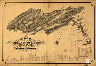
Description: "A map of the Virginia Central Railroad, west of the Blue Ridge, and the preliminary surveys, with a profile of the grades."
Title: 1860 Map of the Virginia Central Railroad
Credit: This map is available from the United States Library of Congress's Geography & Map Division under the digital ID g3881p.rr006020. This tag does not indicate the copyright status of the attached work. A normal copyright tag is still required. See Commons:Licensing for more information.
Author: Map created by Citti, L. F.
Usage Terms: Public domain
License: Public domain
Attribution Required?: No
Image usage
The following page links to this image:

All content from Kiddle encyclopedia articles (including the article images and facts) can be freely used under Attribution-ShareAlike license, unless stated otherwise.