
Image: 2002 Satellite Image of Southern Africa

Size of this preview: 784 × 600 pixels. Other resolutions: 314 × 240 pixels | 6,800 × 5,200 pixels.
Original image (6,800 × 5,200 pixels, file size: 4.36 MB, MIME type: image/jpeg)
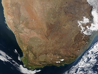
Description: An image of Southern Africa from August 2002, showing parts of (L to R) Namibia, Botswana, Lesotho, Swaziland, Zimbabwe, Mozambique, as well as South Africa.
Title: 2002 Satellite Image of Southern Africa
Credit: https://visibleearth.nasa.gov/view.php?id=61535
Author: Jacques Descloitres
Usage Terms: Public domain
License: Public domain
Attribution Required?: No
Image usage
The following page links to this image:

All content from Kiddle encyclopedia articles (including the article images and facts) can be freely used under Attribution-ShareAlike license, unless stated otherwise.