
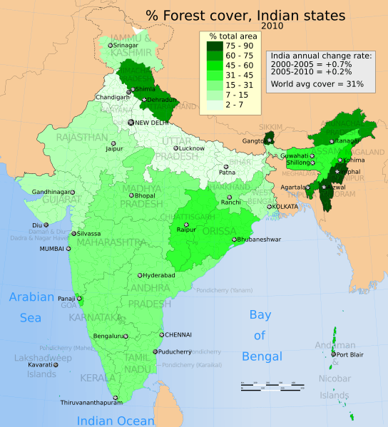
Image: 2010 India forest cover distribution map for its States and Union Territories

Description: The map shows the percent geographical area of each state and UT of India that is covered by forest. The definition of forest includes primary and secondary, protected national parks, set aside forests and any unprotected dense tree cover that is over 1 hectare. The regional forest coverage data is derived from high resolution satellite imaging in 2010. The annual change rate of forest cover trend data is based on annual satellite data as well. Data Sources: 1. All Indian states and UTs forest cover data for 2010 is from India State of Forest Report 2011, Forest Survey of India (2011), pages 4-5, Ministry of Environment & Forests, Government of India.
2. The world's average forest coverage data, as well as India's annual increase in forest trend between 2000-2005 and 2005-2010, is from Global Forest Resources Assessment 2010, FAO Forestry Paper 163, Food and Agriculture Organization of the United Nations (2011), ISBN 978-92-5-106654-6.
The disputed national borders SVG code in this map is a derivative work of File:India literacy rate map en.svg available on wikimedia commons.
Author: M Tracy Hunter
Usage Terms: Creative Commons Attribution-Share Alike 3.0
License: CC-BY-SA-3.0
License Link: http://creativecommons.org/licenses/by-sa/3.0/
Attribution Required?: Yes
Image usage
There are no pages that link to this image.
