
Image: 20210331 Global tree cover loss - World Resources Institute

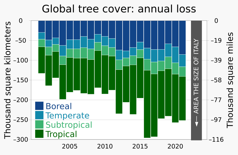
Description: Stacked column chart showing annual loss of tree cover, globally, based on World Resources Institute data published on Mongabay. Data source including 2021 data: https://research.wri.org/gfr/forest-extent-indicators/forest-loss (includes four categories versus two categories for last year's version). Archive of 1 Sept 2022: https://web.archive.org/web/20220901033248/https://research.wri.org/gfr/forest-extent-indicators/forest-loss In Version 7, I changed the order of the categories to be sequential (start with poles, work toward equator): Boreal, Temperate, Subtropical, Tropical. Data source for first upload through 2020 data: Forest Loss / How much tree cover is lost globally each year?. research.WRI.org. World Resources Institute — Global Forest Review (January 2021). Archived from the original on 10 March 2021. Graphed in: Butler, Rhett A. (31 March 2021). "Global forest loss increases in 2020". Mongabay, World Resources Institute. Area of Italy (116,631 sq. mi.): Italy at Britannica.com, archived 23 April 2021.
Author: RCraig09
Usage Terms: Creative Commons Attribution-Share Alike 3.0
License: CC-BY-SA-3.0
License Link: http://creativecommons.org/licenses/by-sa/3.0/
Attribution Required?: Yes
Image usage
The following page links to this image:
