
Image: Abolition of slavery in the United States SVG map

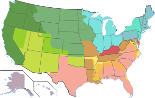
Description: Abolition of slavery in the various states of the US, coded according to the date and (in some cases) manner by which slavery was abolished: Abolition of slavery during or shortly after the American Revolution (Vermont, 1777; Pennsylvania, 1780; Massachusetts [including Maine], 1783; New Hampshire, 1783; Connecticut [including the Western Reserve], 1784; Rhode Island, 1784 The Northwest Ordinance, 1787: applied to what are now Ohio, Indiana, Michigan, Illinois, Wisconsin, and northeastern Minnesota Gradual emancipation in New York (starting 1799, ended 1827) and New Jersey (starting 1804; ended by Thirteenth Amendment, 1865) The Missouri Compromise, 1821: applied to what are now Iowa, western and southern Minnesota, the Dakotas, Nebraska, the part of Kansas then belonging to the US, the northern part of Oklahoma, and the parts of Montana and Wyoming lying east of the Continental Divide; explicitly repealed in 1850, but efforts to introduce slavery were effectively foiled until the abolition of slavery in the territories, 16 April 1862 Effective abolition of slavery by Mexican or joint US/British authority: California: slavery was abolished by the constitution of Mexico, 1821, followed by statehood as a free state in 1850 without an organized territorial stage Oregon Country: slavery was not admitted by either US or British authority DC: Probibition of slave trade in the District of Columbia, 1850 (not shown) Abolition of slavery by Congressional action during the Civil War (1861): Admission of Kansas as a free state, 1861 (efforts to admit Kansas as a slave state under the bogus w:Lecompton Constitution having failed during the 1850s) Organization of Colorado, Nevada, and Dakota territories without slavery Nevada Territory: slavery was abolished by the constitution of Mexico, 1821, and never introduced by American settlers to any significant extent; organized as a free territory on 2 March 1861, Nevada became a free state on 31 Oct 1864 Colorado Territory: slavery was excluded by the Missouri Compromise (north and east) or abolished by the constitution of Mexico, 1821 (west and south), and never introduced by American settlers to any significant extent; Colorado was organized as a free territory on 28 Feb 1861 Abolition of slavery by Congressional action during the Civil War (1862): DC: abolition of slavery in District of Columbia, 16 April 1862 abolition of slavery in the territories, 19 July 1862 (also Arizona Organic Act, 1863) Utah Territory: slavery was abolished by the constitution of Mexico, 1821, but reintroduced by American settlers (officiously through the Compromise of 1850, then by statute in 1852) before being abolished in the territories, 19 July 1862 New Mexico Territory: slavery was abolished by the constitution of Mexico, 1821, but reintroduced by American settlers (officiously through the Compromise of 1850, then by statute in 1859) before being abolished in the territories, 19 July 1862 Emancipation Proclamation as originally issued, 1 Jan 1863 Subsequent operation of the Emancipation Proclamation in 1863 Abolition of slavery by state action during the Civil War: Abolition of slavery in the portions of Virginia exempted from the Emancipation Proclamation (by the Restored Government), 7 April 1864 Organization of Arkansas as a free state, 11 April 1864 Organization of Louisiana as a free state, 19 Sep 1864 Abolition of slavery in Maryland, 1 Nov 1864 Abolition of slavery in Missouri, 11 Jan 1865 Abolition of slavery in West Virginia, 3 Feb 1865 Organization of Tennessee as a free state, 25 Feb 1865 Operation of the Emancipation Proclamation in 1864 Operation of the Emancipation Proclamation in 1865 Thirteenth Amendment to the US constitution, 18 Dec 1865 (abolishes slavery in Delaware and Kentucky) Alaska and Hawai‘i: territory incorporated into the US after the passage of the Thirteenth Amendment
Title: Abolition of slavery in the United States SVG map
Credit: Own work Base map derived from File:Blank US Map with borders.svg by User:Strafpeloton2. For states and counties exempted from the Emancipation Proclamation, I consulted File:Emancipation Proclamation.PNG; battle lines as of January 1, 1863, are based partly on File:Map of American Civil War in 1862.svg (reflecting battle lines at the end of the year 1862).
Author: QuartierLatin1968
Usage Terms: Creative Commons Attribution-Share Alike 4.0
License: CC BY-SA 4.0
License Link: https://creativecommons.org/licenses/by-sa/4.0
Attribution Required?: Yes
Image usage
The following 3 pages link to this image:
