
Image: Administrative map of the United Mongol Autonomous Government

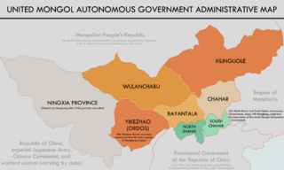
Description: A map of the United Mongol Autonomous Government (Mengjiang) including its provinces, territorial claims, and associated states. The information for this map is mostly from here (http://mbook.kongfz.com/item_pic_26080_611227096/) and here (File:Mengjiang,_North_Shanxi,_South_Chahar_Map_-_Circa_1937-1939.png), which was used to create this map. The names and borders of the provinces are from this link (File:Mengjiang,_North_Shanxi,_South_Chahar_Map_-_Circa_1937-1939.png), which is a map of Mengjiang that I already uploaded.
Title: Administrative map of the United Mongol Autonomous Government
Credit: Own work
Author: Khu'hamgaba Kitap
Usage Terms: Creative Commons Attribution-Share Alike 4.0
License: CC BY-SA 4.0
License Link: https://creativecommons.org/licenses/by-sa/4.0
Attribution Required?: Yes
Image usage
The following page links to this image:
