
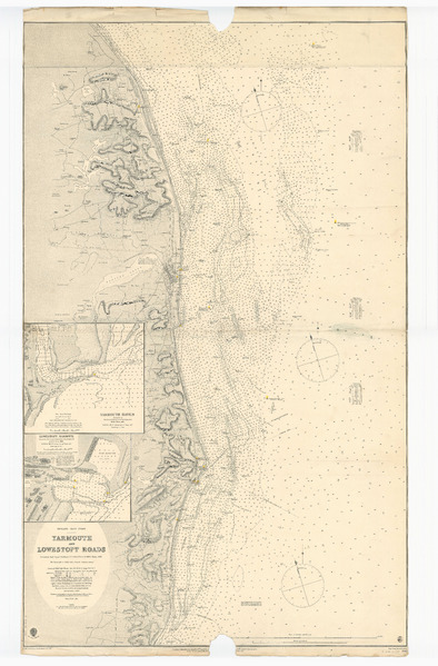
Image: Admiralty Chart No 1543 England - east coast, Yarmouth and Lowestoft Roads surveyed by Staff Comr. T.H. Tizard, R.N. and the officers of H.M.S. "Triton" 1885 RMG L1221, Published 1886f
Description: England - east coast, Yarmouth and Lowestoft Roads surveyed by Staff Comr. T.H. Tizard, R.N. and the officers of H.M.S. "Triton" 1885Scale: 1:41,720. Two insets. Lights coloured. Ungraduated Insets: 1. Yarmouth Haven, 1885 [circa 1:4,000]; 2. Lowestoft Harbour, 1885 [circa 1:4,000] British Admiralty Chart 1543. Yarmouth and Lowestoft Roads. Published 1886
Title: Admiralty Chart No 1543 England - east coast, Yarmouth and Lowestoft Roads surveyed by Staff Comr. T.H. Tizard, R.N. and the officers of H.M.S. "Triton" 1885 RMG L1221, Published 1886
Credit: http://collections.rmg.co.uk/collections/objects/544296
Author: British Admiralty; Captain Thomas Henry Tizard; Davies & Company
Permission: The original artefact or artwork has been assessed as public domain by age, and faithful reproductions of the two dimensional work are also public domain. No permission is required for reuse for any purpose. The text of this image record has been derived from the Royal Museums Greenwich catalogue and image metadata. Individual data and facts such as date, author and title are not copyrightable, but reuse of longer descriptive text from the catalogue may not be considered fair use. Reuse of the text must be attributed to the "National Maritime Museum, Greenwich, London" and a Creative Commons CC-BY-NC-SA-3.0 license may apply if not rewritten. Refer to Royal Museums Greenwich copyright.
Usage Terms: Public domain
License: Public domain
Attribution Required?: No
Image usage
The following page links to this image:
