
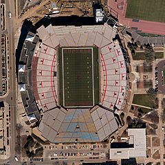
Image: Aerial view of Stadium Memorial, Lincoln

Size of this preview: 600 × 600 pixels. Other resolutions: 240 × 240 pixels | 4,000 × 4,000 pixels.
Original image (4,000 × 4,000 pixels, file size: 11.28 MB, MIME type: image/jpeg)
Description: Aerial view of Stadium Memorial, Lincoln. This image is a High Resolution Orthoimagery, 6-inch spatial resolution, Lancaster County Dataset, taken in April 2007. High Resolution Orthoimagery looks like a photograph but any distortions caused by the tilt of the camera or topography of the land have been removed, so orthoimages are geospatially accurate and can be used as maps.
Title: Aerial view of Stadium Memorial, Lincoln
Credit: http://gallery.usgs.gov/photos/01_29_2013_sXNa6EDqp3_01_29_2013_0#.VChUu2ddUtB
Author: USGS
Usage Terms: Public domain
License: Public domain
Attribution Required?: No
Image usage
The following page links to this image:

All content from Kiddle encyclopedia articles (including the article images and facts) can be freely used under Attribution-ShareAlike license, unless stated otherwise.