
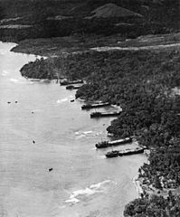
Image: Aerial view of shoreline of Saidor

Size of this preview: 497 × 600 pixels. Other resolutions: 199 × 240 pixels | 746 × 900 pixels.
Original image (746 × 900 pixels, file size: 123 KB, MIME type: image/jpeg)
Description: Aerial view of shoreline of Saidor, New Guinea, showing LSTs unloading equipment on 2 January 1944.
Title: Aerial view of shoreline of Saidor
Credit: http://www.32nd-division.org/history/ww2/saidor/saidor2.jpg
Author: United States Army Signal Corps
Usage Terms: Public domain
License: Public domain
Attribution Required?: No
Image usage
The following page links to this image:

All content from Kiddle encyclopedia articles (including the article images and facts) can be freely used under Attribution-ShareAlike license, unless stated otherwise.