
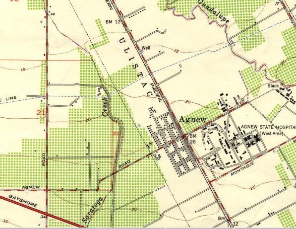
Image: Agnew California map (USGS 1953)
No higher resolution available.
Agnew_California_map_(USGS_1953).jpg (597 × 461 pixels, file size: 81 KB, MIME type: image/jpeg)
Description: U.S. Geological Survey map from 1953, showing the former Agnew's Village, California. The village is noted where Agnew Rd crosses the Southern Pacific railroad track (running parallel to Lafayette Ave.), in Santa Clara, California. USGS legend (top): MILPITAS QUADRANGLE CALIFORNIA 7.5 MINUTE SERIES (TOPOGRAPHIC) NW/4 SAN JOSE 15' QUADRANGLE USGS legend (bottom): MILPITAS, CALIF. NW/4 SAN JOSE 15' QUADRANGLE N3722.5—W12152.5/7.5 1953
Title: Agnew California map (USGS 1953)
Credit: http://sunsite2.berkeley.edu:8088/xdlib//maps/brk00010.00000081.xml UC Berkeley holding no.: C039141491
Author: U.S. Geological Survey
Usage Terms: Public domain
License: Public domain
Attribution Required?: No
Image usage
The following page links to this image:

All content from Kiddle encyclopedia articles (including the article images and facts) can be freely used under Attribution-ShareAlike license, unless stated otherwise.
.jpg)