
Image: Aroya, Colorado vicinity map

Size of this preview: 800 × 564 pixels. Other resolutions: 320 × 225 pixels | 1,002 × 706 pixels.
Original image (1,002 × 706 pixels, file size: 154 KB, MIME type: image/png)
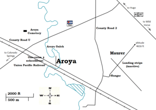
Description: A map of the vicinity of Aroya, Colorado, including roads and highways, the Aroya Gulch, the one-room schoolhouse, the cemetery, the railroad, and the airfield. Created using Inkscape v0.48 from the information in http://www.trails.com/usgs-topo-aroya-populated-place-topographic-map-195190.html.
Title: Aroya, Colorado vicinity map
Credit: Own work
Author: Obankston
Usage Terms: Creative Commons Attribution-Share Alike 3.0
License: CC BY-SA 3.0
License Link: http://creativecommons.org/licenses/by-sa/3.0
Attribution Required?: Yes
Image usage
The following page links to this image:

All content from Kiddle encyclopedia articles (including the article images and facts) can be freely used under Attribution-ShareAlike license, unless stated otherwise.