
Image: Australia discoveries by Europeans before 1813 en

Size of this preview: 651 × 599 pixels. Other resolutions: 261 × 240 pixels | 1,200 × 1,105 pixels.
Original image (1,200 × 1,105 pixels, file size: 1.47 MB, MIME type: image/png)
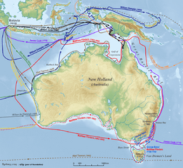
Description: Map of European exploration of Australia in the years before 1813
Title: Australia discoveries by Europeans before 1813 en
Credit: "own work", used: Generic Mapping Tools and SRTM30 http://www.australiaoncd.com.au/discovery/duyfken_chart.jpg Tasmanroutes.PNG by User:Maksim Bass-map.jpg by User:Roke Dampier-map.jpg by User:Roke Torres-map.jpg by Project Gutenberg Australia
Author: Lencer
Usage Terms: Creative Commons Attribution-Share Alike 3.0
License: CC BY-SA 3.0
License Link: http://creativecommons.org/licenses/by-sa/3.0
Attribution Required?: Yes
Image usage
There are no pages that link to this image.

All content from Kiddle encyclopedia articles (including the article images and facts) can be freely used under Attribution-ShareAlike license, unless stated otherwise.