
Image: Austria-Hungary map

Size of this PNG preview of this SVG file: 776 × 600 pixels. Other resolution: 311 × 240 pixels.
Original image (SVG file, nominally 783 × 605 pixels, file size: 331 KB)
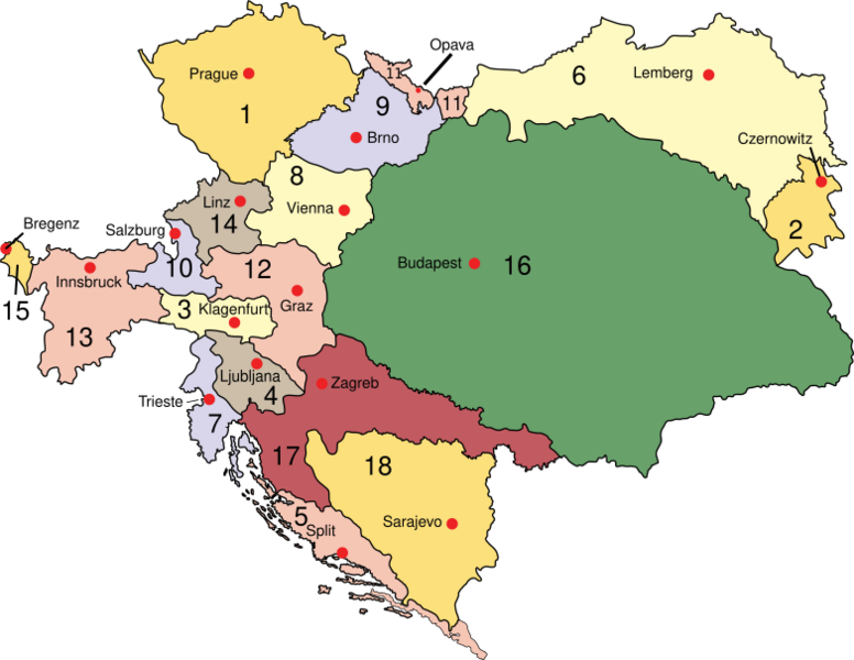
Description: Austria Empire of Austria (Cisleithania): 1. Bohemia, 2. Bukovina, 3. Carinthia, 4. Carniola, 5. Dalmatia, 6. Galicia, 7. Küstenland, 8. Lower Austria, 9. Moravia, 10. Salzburg, 11. Silesia, 12. Styria, 13. Tyrol, 14. Upper Austria, 15. Vorarlberg; Kingdom of Hungary (Transleithania): 16. Hungary 17. Croatia-Slavonia; Austrian Condominium: 18. Bosnia and Herzegovina
Title: Austria-Hungary map
Credit: Own work (at English wikipedia)
Author: IMeowbot
Usage Terms: Public domain
License: Public domain
Attribution Required?: No
Image usage
The following page links to this image:

All content from Kiddle encyclopedia articles (including the article images and facts) can be freely used under Attribution-ShareAlike license, unless stated otherwise.