
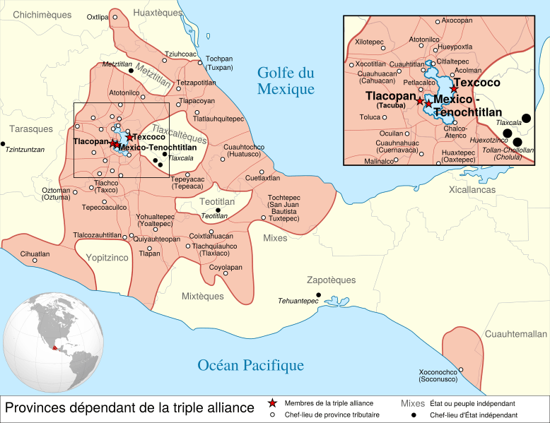
Image: Aztec Empire 1519 map-fr

Description: Map of the Aztec Empire lead by Tenochtitlan circa 1519, before the arrival of the Spanish.
Title: Aztec Empire 1519 map-fr
Credit: Provincias_tributarias_de_la_Triple_Alianza_(s._XVI).svg, from the Atlas del México prehispánico, special edition of Arqueología Mexicana, 2000-07-05, México. Aztec_Empire_(orthographic_projection).svg
Author: Provincias_tributarias_de_la_Triple_Alianza_(s._XVI).svg: Yavidaxiu Aztec_Empire_(orthographic_projection).svg: File:Provincias tributarias de la Triple Alianza (s. XVI).svg : Yavidaxiu File:Mexico (orthographic projection).svg : Ssolbergj Derivative work : Keepscases and Sémhur
Usage Terms: Creative Commons Attribution-Share Alike 3.0
License: CC BY-SA 3.0
License Link: http://creativecommons.org/licenses/by-sa/3.0
Attribution Required?: Yes
Image usage
The following 2 pages link to this image:
