
Image: Battle of Basque Roads 11 April

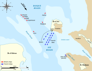
Description: Map of the Battle of Basque Roads, 1809; a naval battle of the Napoleonic wars fought between the British and the French. The map illustrates the position of the anchored French fleet south of the Île-d'Aix shortly before the British launched a fire ship attack on the night of 11 April.
Title: Battle of Basque Roads 11 April
Credit: Own work based on text, maps and charts from: Detailed plan of attack on Aix Roads, engraved by Simpkin after original by Fairfax published by Joyce Gold (1809), (from the Naval Chronicle, Vol XII) Clowes, William Laird (1997 [1900]) The Royal Navy, A History from the Earliest Times to 1900, Volume V, Chatham Publishing Cordingly, David (2007) Cochrane the Dauntless, London: Bloomsbury Publishing James, William (1826) The Naval History of Great Britain, Volume 5, 1808–1811, Harding, Lepard, and Co Map icons from: File:Maps template-en.svg
Author: BarretBonden
Usage Terms: Creative Commons Attribution-Share Alike 3.0
License: CC BY-SA 3.0
License Link: https://creativecommons.org/licenses/by-sa/3.0
Attribution Required?: Yes
Image usage
The following page links to this image:
