
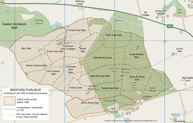
Image: Bedford Purlieus map showing former woodland

Description: Map of Bedford Purlieus, ancient woodland near Peterborough, Cambridgeshire, UK. As well as the present-day woods, it shows the area of former woodland, grubbed up in the 1860s. The compartment boundaries and rides, from an estate map of 1757, are also included.
Title: Bedford Purlieus map showing former woodland
Credit: Ordnance Survey data © Crown copyright and database right 2011 available under OS Opendata, from the raster format of OS VectorMap District, SF and SP, downloadable from https://www.ordnancesurvey.co.uk/opendatadownload/products.html. The compartment and ride data is from an estate map of 1757, as redrawn by Rixen, P, (1975) in Peterken, G.F. & Welch, R.C., BEDFORD PURLIEUS: its History Ecology and Management. [1]
Author: Robin Stevenson based on Ordnance Survey data © Crown copyright and database right 2011 under UK Open Government licence at http://www.nationalarchives.gov.uk/doc/open-government-licence/open-government-licence.htm
Usage Terms: Ordnance Survey OpenData Licence
License: OS OpenData
License Link: https://www.ordnancesurvey.co.uk/business-and-government/licensing/using-creating-data-with-os-products/os-opendata.html
Attribution Required?: Yes
Image usage
The following page links to this image:
