
Image: Bilis TRMM
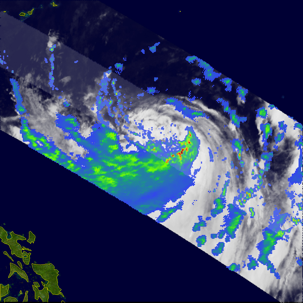
Description: Although the center of Tropical Storm Bilis (known as Florita in the Philippines) passed well to the north of Luzon, it has been blamed for at least 14 fatalities on the island as a result of flash floods, mudslides, and wind damage. The storm formed as a tropical depression on July 8, 2006, south of Guam. The depression intensified into a tropical storm the following day as it crossed the central Philippine Sea and assumed a more northwesterly track. The Tropical Rainfall Measuring Mission (TRMM) satellite observed Bilis on July 10, 2006, at 21:37 UTC, as the storm was passing through the Philippine Sea well northeast of the islands. The image shows the horizontal distribution of rain intensity within the storm as seen from the TRMM satellite. Rain rates in the center swath are from the TRMM Precipitation Radar, while rain rates in the outer swath are from the TRMM Microwave Imager. The rain rates are overlaid on infrared data from the TRMM Visible Infrared Scanner. In this image, Bilis appears as a highly asymmetrical storm, with the vast majority of the rain occurring south of the center in a rather large band (broad green and blue area). The actual center itself was rather poorly defined. Near the time of this image, the Joint Typhoon Warning Center estimated the maximum sustained winds to be 92 kilometers per hour (58 miles per hour), the equivalent of a moderate tropical storm. As Bilis continued to track to the northwest, this band of rain and its associated circulation came ashore over Luzon in the northern Philippines. Although the storm’s center remained well off the coast, the interaction of heavy rain and mountainous terrain led to flash flooding and mudslides. The Tropical Rainfall Measuring Mission satellite (known as TRMM) was placed into service in November of 1997. From its low-earth orbit, TRMM has been providing valuable images and information on storm systems around the Tropics using a combination of passive microwave and active radar sensors, including the first precipitation radar in space. TRMM is a joint mission between NASA and the Japanese space agency, JAXA.
Title: Bilis TRMM
Credit: http://earthobservatory.nasa.gov/NaturalHazards/natural_hazards_v2.php3?img_id=13711
Author: Images produced by Hal Pierce (SSAI/NASA GSFC) and caption by Steve Lang (SSAI/NASA GSFC).
Permission: This file is in the public domain in the United States because it was solely created by NASA. NASA copyright policy states that "NASA material is not protected by copyright unless noted". (See Template:PD-USGov, NASA copyright policy page or JPL Image Use Policy.) Warnings: Use of NASA logos, insignia and emblems is restricted per U.S. law 14 CFR 1221. The NASA website hosts a large number of images from the Soviet/Russian space agency, and other non-American space agencies. These are not necessarily in the public domain. Materials based on Hubble Space Telescope data may be copyrighted if they are not explicitly produced by the STScI.[1] See also and Template:Cc-Hubble. The SOHO (ESA & NASA) joint project implies that all materials created by its probe are copyrighted and require permission for commercial non-educational use. [2] Images featured on the Astronomy Picture of the Day (APOD) web site may be copyrighted. [3] The National Space Science Data Center (NSSDC) site has been known to host copyrighted content even though its photo gallery FAQ states that all of the images in the photo gallery are in the public domain.
Usage Terms: Public domain
License: Public domain
Attribution Required?: No
Image usage
The following image is a duplicate of this image (more details):
There are no pages that link to this image.
