
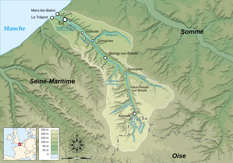
Image: Bresle Drainage Basin-fr

Description: Map showing the drainage basin of the Bresle river, between Picardie and Haute-Normandie, France.
Title: Bresle Drainage Basin-fr
Credit: Data sources: Background map: Image:Bassin versant de la Bresle.jpg by Antonov14 under CC-BY-3.0 and Image:Location Authie and Bresle River-fr.svg by Sémhur under GFDL & CC-BY-SA-3.0, itself made from data from NASA Shuttle Radar Topography Mission (SRTM3 v.2 & SWDB) (public domain) Locator map made from Blank_map_of_Europe_-_Atelier_graphique_colors.svg created by Historicair under GFDL & CC-BY-SA-2.5 ; compass rose from Compass rose pale.svg (opacified) created by Fibonacci under GFDL ; scale from Image:Scale_kilometres_miles_svg.svg by Sémhur under GFDL & CC-BY-SA-3.0.Softwares used: NASA datas edited with Global Mapper 9 (limited version) by the United States Geological Survey (USGS) Vectorized with Inkscape The Gimp ;Others: UTM map projection WGS84 geodetic system Shaded relief (ligth direction) : altitude 80°, azimuth 315° Fonts: Times New Roman for sea and rivers labels, Arial for others.
Author: Sémhur
Usage Terms: Creative Commons Attribution-Share Alike 4.0
License: CC BY-SA 4.0
License Link: https://creativecommons.org/licenses/by-sa/4.0
Attribution Required?: Yes
Image usage
The following 2 pages link to this image:
