
Image: Bristol UK general election 2015 map

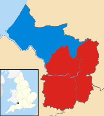
Description: Modified version of File:Bristol_UK_general_election_2010_map.svg with results from the UK general election in May 2015. All other sources and information are as per the original image. Map of Bristol UK, showing the current representation in Parliament as of the elections of May 2010. Blue = Conservative, Red = Labour, Yellow = Liberal Democrat. Equirectangular map projection on WGS 84 datum, with N/S stretched 160% Geographic limits: West: 2.73W East: 2.5W North: 51.55N South: 51.39N
Title: Bristol UK general election 2015 map
Credit: Ordnance Survey OpenData. Most data from Boundary-Line product. Lake data from Meridian 2 product. Inset derived from File:England location map.svg by Spischot.
Author: Nilfanion, created using Ordnance Survey data. Modified by Robomilk.
Usage Terms: Creative Commons Attribution-Share Alike 3.0
License: CC BY-SA 3.0
License Link: http://creativecommons.org/licenses/by-sa/3.0
Attribution Required?: Yes
Image usage
There are no pages that link to this image.
