
Image: Bubonic plague map

Size of this preview: 554 × 599 pixels. Other resolutions: 222 × 240 pixels | 1,024 × 1,108 pixels.
Original image (1,024 × 1,108 pixels, file size: 184 KB, MIME type: image/png)
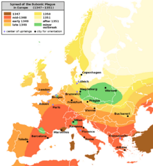
Description: Bubonic Plague Map – with English text Spreading of the Bubonic Plague in Europe between 1347 and 1351 Note: The borders on the map illustrate present day borders, not those of the late 1340s!
Title: Bubonic plague map
Credit: Translation of this: de-Wikipedia German map into English For the de-WP-image: Atlas zur Weltgeschichte (Atlas of World History)
Author: Original by Roger Zenner (de-WP) Enlarging & readability editing by user Jaybear
Usage Terms: Creative Commons Attribution-Share Alike 3.0
License: CC-BY-SA-3.0
License Link: http://creativecommons.org/licenses/by-sa/3.0/
Attribution Required?: Yes
Image usage
The following 2 pages link to this image:

All content from Kiddle encyclopedia articles (including the article images and facts) can be freely used under Attribution-ShareAlike license, unless stated otherwise.