
Image: Burr The State of Texas, 1835-1845 1846 UTA

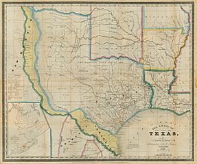
Description: Engraved by S. Stiles & Co. This historically-themed map is one of the first printed maps to show the former Texas republic and Mexican province as a state, and the map's distinct hand coloring well illustrates disputed areas (in yellow) claimed by both the Texas (and now U.S.) and Mexican governments from the time of Texas independence in 1836 to the eve of the U.S. War with Mexico in 1846. The cartographer, David H. Burr, was geographer to the U.S. House of Representatives (1838-1847) and before that had been topographer to the U.S. Post Office Department (1832-1838). As early as 1833 Burr issued a similar map based in part on Stephen F. Austin's and Henry S. Tanner's 1830 map of Texas. One of Burr's innovations then was to include an inset "Plan of the Port of Galveston, Made by order of the Mexican Government by Alexander Thompson of the Mexican Navy in 1828," seen at lower left. As Texas passed from Mexican province (technically part of the state of Coahuila y Texas) to an independent republic and then a state, Burr continued to update his own maps, but he also kept many of the original features of the first edition. As examples, Burr's 1833 edition had several of the Mexican-Anglo land grants but did not have the counties, the latest addition on this 1846 map being the 1843 addition of Rusk County in the east. In 1846 Burr continued to show a "Spanish Garrison" and a "Cherokee Village" long after these features had disappeared, but he also added newer towns and villages such as Austin, Crockett, and Texana, that had been established during the years of the republic. Burr also noted the location of copper and silver mines in west central Texas, but not enough of these resources were ever found to make commercial mining of them viable.
Title: The State of Texas, 1836-1845
Credit: UTA Libraries Cartographic Connections: map / text
Author: David H. Burr
Usage Terms: Public domain
License: Public domain
Attribution Required?: No
Image usage
The following page links to this image:
