
Image: Caribou Inuit bands map

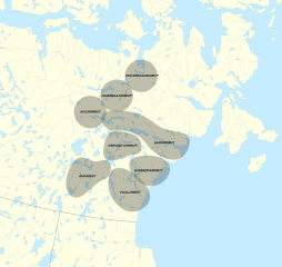
Description: Location of Caribou Inuit bands at the end of the 19th century Sources: Harris, Julie “Cultural Heritage and Interpretative Materials Study.” Page 13. [1]Henderson, Lyle. “The Arvia’juaq And Qikiqtaarjuk Oral History Project.” Page 199.[2][3]Keith, Darren “Caribou, river and ocean: Harvaqtuurmiut landscape organization and orientation.” https://www.erudit.org/en/journals/etudinuit/2004-v28-n2-etudinuit1289/013195ar/Kigjugalik Hughson, Paula. “Our homeland for the past, present and future: Akulliqpaaq Qamaniq (Aberdeen Lake) and Qamaniq Tugliqpaaq (Schultz Lake) landscapes described by Elder John Killulark.” Page 6. [4]Stewart, Andrew M. “Archaeology and Oral History of Inuit Land Use on the Kazan River, Nunavut: A Feature-based Approach”[5] This file was derived from: Canada Nunavut location map-lambert proj2.svg
Title: Caribou Inuit bands map
Credit: Own work
Author: Noahedits
Usage Terms: Creative Commons Attribution-Share Alike 4.0
License: CC BY-SA 4.0
License Link: https://creativecommons.org/licenses/by-sa/4.0
Attribution Required?: Yes
Image usage
The following page links to this image:
