
Image: Chadwick's Bethnal Green Parish map. Wellcome L0009782

Size of this preview: 741 × 600 pixels. Other resolutions: 297 × 240 pixels | 3,572 × 2,892 pixels.
Original image (3,572 × 2,892 pixels, file size: 4.15 MB, MIME type: image/jpeg)
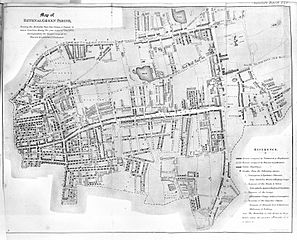
Description: Bethnal Green Parish map. Wellcome Images Keywords: topography; Sanitation; Great Britain; London; Edwin Chadwick
Title: Chadwick's Bethnal Green Parish map.
Credit: https://wellcomeimages.org/indexplus/obf_images/bc/93/715934a46704d1a2b85b4035f7e6.jpg Gallery: https://wellcomeimages.org/indexplus/image/L0009782.html Wellcome Collection gallery (2018-03-27): https://wellcomecollection.org/works/azajcqdq CC-BY-4.0
Usage Terms: Creative Commons Attribution 4.0
License: CC BY 4.0
License Link: https://creativecommons.org/licenses/by/4.0
Attribution Required?: Yes
Image usage
The following page links to this image:

All content from Kiddle encyclopedia articles (including the article images and facts) can be freely used under Attribution-ShareAlike license, unless stated otherwise.