
Image: Chattanooga Shale (Upper Devonian; Burkesville West Rt. 90 roadcut, Kentucky, USA) 17 (40541683280)

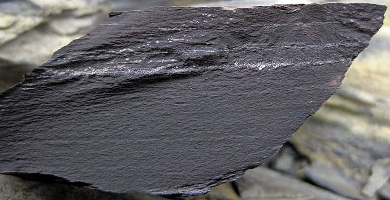
Description: Shales in the Devonian of Kentucky, USA. (cross-section view) The dark area seen here is a crack surface of unweathered black shale with light-colored stringers of finely-crystalline pyrite (FeS2 - iron sulfide; "fool's gold"). The Chattanooga Shale of Kentucky and Tennessee consists of dark-colored, chippy-weathering, marine mudshales of Late Devonian age. These black shales were deposited in a moderately deep, anoxic seafloor environment. This was a widespread lithofacies during the Late Devonian's Global Anoxia Event. The Chattanooga Shale is equivalent to the Ohio Shale, the Antrim Shale, and the New Albany Shale in surrounding states. Stratigraphy: Chattanooga Shale, Upper Devonian Locality: roadcut on the northern side of Route 90, just west of Burkesville, central Cumberland County, southern Kentucky, USA (36° 47’ 51.17” North latitude, 85° 23’ 10.62” West longitude)
Title: Chattanooga Shale (Upper Devonian; Burkesville West Rt. 90 roadcut, Kentucky, USA) 17 (40541683280)
Credit: Chattanooga Shale (Upper Devonian; Burkesville West Rt. 90 roadcut, Kentucky, USA) 17
Author: James St. John
Usage Terms: Creative Commons Attribution 2.0
License: CC BY 2.0
License Link: https://creativecommons.org/licenses/by/2.0
Attribution Required?: Yes
Image usage
The following page links to this image:

_17_(40541683280).jpg)