
Image: Chertified fossiliferous limestone (Ft. Payne Limestone, Lower Mississippian; Lake Cumberland, Kentucky, USA) 2 (30748692874)

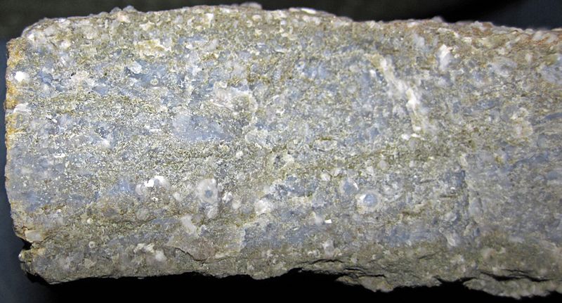
Description: Chertified fossiliferous limestone from the Mississippian of Kentucky, USA. (cross-section view) The Ft. Payne Formation of southern Kentucky is richly fossiliferous and is dominated by crinoids. Crinoids ("sea lilies") are sessile, benthic, filter-feeding, marine invertebrates that were abundant in Paleozoic oceans. The group nearly went extinct at the Permian-Triassic mass extinction 251 million years ago. Crinoids are not common in modern oceans - they are usually deep-water forms now, but some shallow-water forms also exist today. A crinoid is essentially a starfish on a stick. The stick, or stem, lifts the organism to a moderately high tier above the seafloor, which is conducive to non-competitive filter feeding. The flower-like "head" of the crinoid consists of numerous cemented calcite plates that surround the digestive system and other soft parts. The arms are feather-like and are the structures that engage in filter-feeding. In the fossil record, crinoid stems are common, whereas crinoid heads are uncommon to rare, because they disaggregate quickly after death. Individual pieces of a crinoid stem are called columnals - they are usually somewhat shaped like poker chips. Each columnal is composed of a single crystal of calcite (CaCO3 - calcium carbonate). The fossiliferous limestone shown above is dominated by crinoid stem columnals. Such crinoid-rich limestones are called "encrinites". The slightly bluish-gray material is chert - the original limestone has been mostly chertified. Classification: Animalia, Echinodermata, Crinoidea Stratigraphy: packstone buildup in the Ft. Payne Formation, Osagean Stage, upper Lower Mississippian Locality: Cave Springs South Outcrop - lakeside outcrop, north-central Lake Cumberland, just south of the intersection of the Wolf Creek/Caney Creek arm of Lake Cumberland with Lake Cumberland proper, Russell County, southern Kentucky, USA (vicinity of 36° 56' 26.59" North latitude, 85° 00' 25.44" West longitude) See info. at: <a href="https://en.wikipedia.org/wiki/Encrinite" rel="nofollow">en.wikipedia.org/wiki/Encrinite</a>
Title: Chertified fossiliferous limestone (Ft. Payne Limestone, Lower Mississippian; Lake Cumberland, Kentucky, USA) 2 (30748692874)
Credit: Chertified fossiliferous limestone (Ft. Payne Limestone, Lower Mississippian; Lake Cumberland, Kentucky, USA) 2
Author: James St. John
Usage Terms: Creative Commons Attribution 2.0
License: CC BY 2.0
License Link: https://creativecommons.org/licenses/by/2.0
Attribution Required?: Yes
Image usage
The following page links to this image:

_2_(30748692874).jpg)