
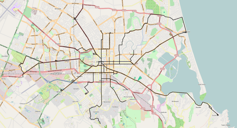
Image: Christchurch CTB tramway route map

Description: Route map of the electrified tramway system of the Christchurch Tramway Board in Christchurch, New Zealand. N.B. The base road map used here is for reference only and no attempt has been made to make it commensurate with the era in which the tramway operated. Also, as this is a route map, some tracks that existed for operational reasons only, including but not necessarily limited to: sidings, loops, or other configurations to quarries, ballast pits, car sheds, depots, or other facilities, have been omitted. Disclaimer: While I have endeavoured to ensure the accuracy of this map, it may not always be 100% historically accurate, especially the placement, location, orientation, size, or length of balloon loops or wyes at the termini of some lines or where the configuration of roads on which the original tram lines ran has changed since the tram line was removed.
Title: Christchurch CTB tramway route map
Credit: Own work based on map image from OpenStreetMap. Route information courtesy of: Stewart, Graham (1993) The End Of The Penny Section: When Trams Ruled the Streets of New Zealand, Wellington: Grantham House Publishing ISBN: 1 86934 037 X. Transferred from en.wikipedia by SreeBot
Author: Matthew25187 at en.wikipedia
Permission: Base map image © OpenStreetMap contributors, CC-BY-SA.
Usage Terms: Creative Commons Attribution-Share Alike 3.0
License: CC BY-SA 3.0
License Link: https://creativecommons.org/licenses/by-sa/3.0
Attribution Required?: Yes
Image usage
The following page links to this image:
