
Image: Christchurch from space, 4 March 2011, showing quake shaking strength, with key
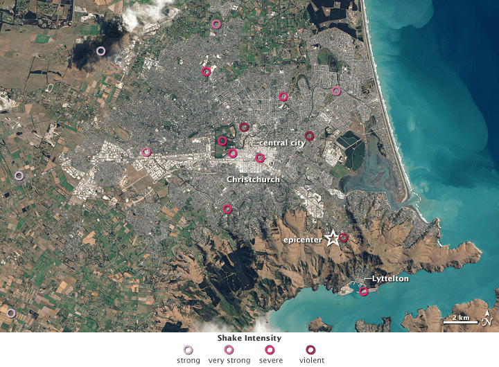
Description: Satellite image of Christchurch and surrounding areas on 4 March 2011, about two weeks after the 2011 Christchurch earthquake. Circle colour indicates shaking strength, with deeper red meaning stronger shaking as shown in the key under the image. NASA's caption: "It is a modern human tendency to focus on the number of an earthquake—specifically, the magnitude, or what people used to call the “Richter scale.” But the destruction from a quake usually has more to do with location and timing. Such was the case with the earthquake in Christchurch, New Zealand, on February 22, 2011. "A September 2010 earthquake centered 40 kilometers (25 miles) west of Christchurch, in the plains near Darfield, struck at 4:35 a.m., had a magnitude of 7.1, and caused some structural damage and one death (by heart attack). The earthquake in February 2011 occurred at 12:51 p.m. and just 10 kilometers (6 miles) from the center of Christchurch. It had a magnitude of 6.3, though was officially classified—scientifically speaking—as an aftershock of the 2010 quake. At least 166 people died, and the city of Christchurch was devastated structurally and emotionally. Many people are still missing. "The natural-color image above was captured on March 4, 2011, by the Advanced Land Imager (ALI) on NASA’s Earth Observing-1 (EO-1) satellite. Overlain on the map [not in this high resolution version] are seismological measurements of the ground shaking in the Christchurch area on February 22, as noted by the U.S. Geological Survey's Earthquake Hazard Program. "The deeper the red color of the circle, the more intense the “peak ground acceleration,” or shaking of the earth. Note how intensity is highest right around the most densely developed areas of Christchurch. City officials and news accounts also described liquefaction—the softening and loosening of the soil due to shaking and groundwater penetration—that was 300 to 500 percent worse than during the September 2010 earthquake. "There are two forms of energy that cause the shaking in an earthquake. “P” or primary waves provide the initial, often vertical, jolt that lifts people and structures off the ground. “S” or secondary waves lead to horizontal shaking. Most structures collapse during the longer-duration S waves because buildings are not designed to handle this side-to-side motion. In Christchurch, the quake occurred so close by that the lag between P and S waves was a mere second."
Title: Christchurch from space, 4 March 2011, showing quake shaking strength, with key
Credit: Christchurch_from_space,_4_March_2011,_showing_quake_shaking_strength.jpg, and shaking strength palette from the same NASA webpage.
Author: Christchurch_from_space,_4_March_2011,_showing_quake_shaking_strength.jpg: NASA Earth Observatory image by Robert Simmon, using ALI data from the EO-1 Team and USGS Earthquake Hazard Program. Caption by Mike Carlowicz. derivative work (combining with key/palette): Avenue (talk)
Usage Terms: Public domain
License: Public domain
Attribution Required?: No
Image usage
The following page links to this image:
