
Image: Christiana-Riot-Map-1851

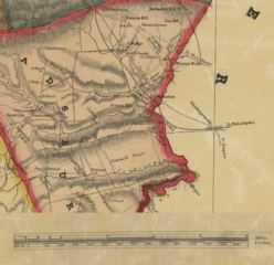
Description: A portion of an 1851 map showing various places of importance for the Christiana Riot. Notably Penningtonville station in Chester county, the community of Christiana in Sadsbury Township (Lancaster county). The Parker house where the attack took place is located in the Pownall Tract.
Title: Christiana-Riot-Map-1851
Credit: A map derived from the Map of Lancaster County, Pennsylvania, published 1851 and held by the Library of Congress https://www.loc.gov/item/2012592191/ The derivation is a small portion of the map depicting Christiana, PA and with the map scale moved to be on this portion.
Author: Original author is not listed. I create the derivation
Usage Terms: Public domain
License: Public domain
Attribution Required?: No
Image usage
The following page links to this image:
