
Image: Cold War Map 1959

Size of this PNG preview of this SVG file: 800 × 406 pixels. Other resolution: 320 × 162 pixels.
Original image (SVG file, nominally 940 × 477 pixels, file size: 853 KB)
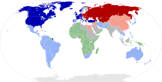
Description: World map showing the two blocs during the Cold War in 1959. NATO member states Other allies of the USA Colonized countries Warsaw Pact member states Other allies of the USSR Non-aligned nations
Title: Cold War Map 1959
Credit: Own work, from : Image:BlankMap-World 1959.svg by Sémhur, under licence GFDL & CC-BY-SA Image:Cold War Map 1959.png by FocalPoint under licence GFDL
Author: Sémhur
Usage Terms: Creative Commons Attribution-Share Alike 4.0
License: CC BY-SA 4.0
License Link: https://creativecommons.org/licenses/by-sa/4.0
Attribution Required?: Yes
Image usage
The following page links to this image:

All content from Kiddle encyclopedia articles (including the article images and facts) can be freely used under Attribution-ShareAlike license, unless stated otherwise.