
Image: Coloradoriverdelta oli APR2020
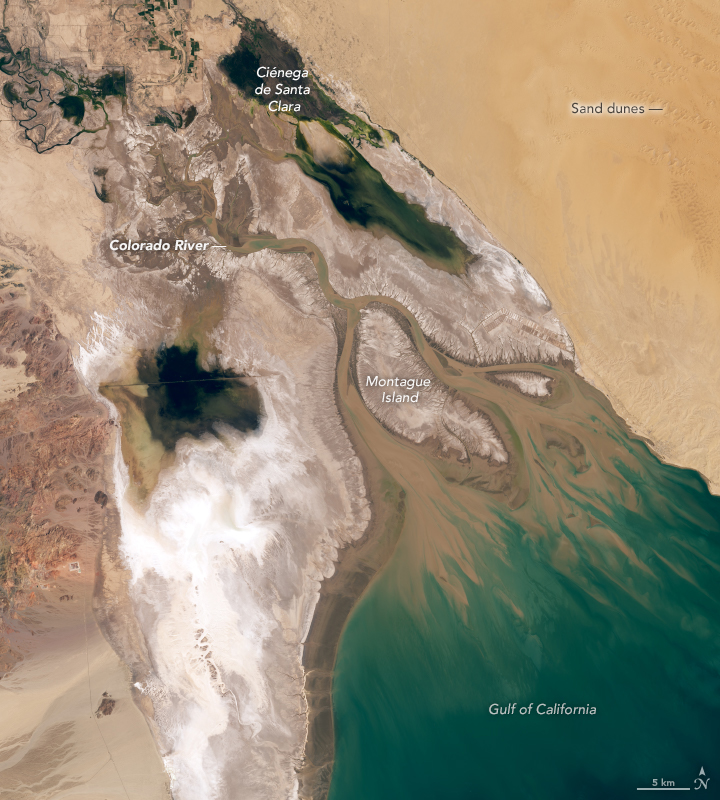
Description: When conservationist Aldo Leopold first paddled the Colorado River Delta in 1922, he was awed by the delta’s seemingly endless maze of green lagoons. “On the map, the Delta was bisected by the river, but in fact the river was nowhere and everywhere,” he wrote in A Sand County Almanac. The wildlife, especially, entranced him. “A verdant wall of mesquite and willow separated the channel from the thorny desert beyond,” he continued. “At each bend we saw egrets standing in the pools ahead, each white statue mashed by its white reflection. Fleets of cormorants drove their black prows in quest of skittering mullets; avocets, willets, and yellow-legs dozed one-legged on the bars; mallards, widgeons, and teal sprang skyward in alarm.” If he were to return and see today’s Colorado River Delta, Leopold would likely be amazed by how much it has changed. With most of the river’s water diverted into an irrigation canal near the U.S. - Mexico border, about 90 percent of the wetlands are gone. The mesquite and willow have largely been replaced by invasive salt cedar. And most of those verdant lagoons have turned into salt flats. Without an influx of nutrients from the river, far fewer species live in the estuary and Gulf of California. In the natural-color satellite image above, the dendritic tidal creeks that flow into the gulf and tidal mudflats look like spindly fingers reaching into the sea. White salt flats and brown, shifting dune fields of the Sonoran Desert flank the delta and Montague Island. The Operational Land Imager (OLI) on Landsat 8 acquired the image on March 20, 2020. There are still a few pockets of green that Leopold might find familiar. One of the largest, the Ciénega de Santa Clara wetland, formed by accident in the 1970s when the United States built a canal that drained salty irrigation runoff from farmland in Arizona. As the new source of moisture poured into the desert, an oasis of reeds, cattails, waterfowl, and other types of wildlife grew up around it, turning it into one of the largest wetlands in the area. Today, 280 species of birds spend their winters there. NASA Earth Observatory images by Lauren Dauphin, using Landsat data from the U.S. Geological Survey. Story by Adam Voiland.
Title: Coloradoriverdelta oli APR2020
Credit: https://earthobservatory.nasa.gov/images/146839/green-lagoons-no-more?src=eoa-iotd
Author: NASA Earth Observatory images by Lauren Dauphin, using Landsat data from the U.S. Geological Survey
Permission: Public domainPublic domainfalsefalse This file is in the public domain in the United States because it was solely created by NASA. NASA copyright policy states that "NASA material is not protected by copyright unless noted". (See Template:PD-USGov, NASA copyright policy page or JPL Image Use Policy.) Warnings: Use of NASA logos, insignia and emblems is restricted per U.S. law 14 CFR 1221. The NASA website hosts a large number of images from the Soviet/Russian space agency, and other non-American space agencies. These are not necessarily in the public domain. Materials based on Hubble Space Telescope data may be copyrighted if they are not explicitly produced by the STScI.[1] See also Template:PD-Hubble and Template:Cc-Hubble. The SOHO (ESA & NASA) joint project implies that all materials created by its probe are copyrighted and require permission for commercial non-educational use. [2] Images featured on the Astronomy Picture of the Day (APOD) web site may be copyrighted. [3] The National Space Science Data Center (NSSDC) site has been known to host copyrighted content. Its photo gallery FAQ states that all of the images in the photo gallery are in the public domain "Unless otherwise noted."
Usage Terms: Public domain
License: Public domain
Attribution Required?: No
Image usage
The following page links to this image:
