
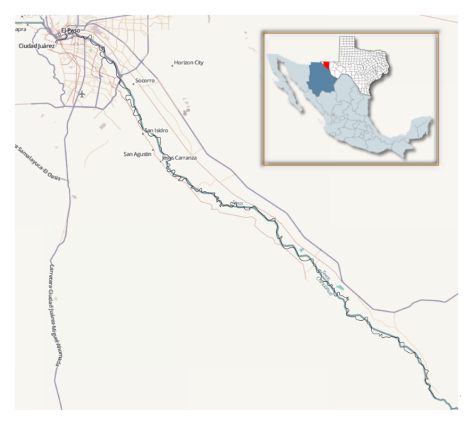
Image: Comparison of the rectified channel of the Rio Grande with a previous natural channel

Description: For the purposes of comparison, I overlaid an OpenStreetMap.org map of the U.S.-Mexico border in the El Paso-Juarez Valley (over the entire distance of the 1935-1938 Rio Grande Rectification from El Paso to Little Box Canyon, south of Fort Quitman). I created an overlay with an Inkscape tracing of the border as it existed well prior to the rectification. I obtained the tracing of the old border from 1908, 1907 and 1894 USGS maps that are available at the "USGS Store" website. In this SVG file, the current border from OpenStreetMap (aquamarine color) is overlaid on its northern half with the border from the 1908 and 1907 maps (black color) and on its southern half with the border being the river as shown in the 1894 map (black color). Note that in the 1908 map of the El Paso Quadrangle, there are several places where the border does not coincide with the then-current course of the Rio Grande, including a significant cut-off area that is too large for the Banco Convention of 1905 to apply. Use suggested at Territorial evolution of the United States
Title: Comparison of the rectified channel of the Rio Grande with a previous natural channel
Credit: http://www.openstreetmap.org and USGS quadrant maps (available at the USGS Store Map Locator & Downloader, http://store.usgs.gov/b2c_usgs/usgs/maplocator/(xcm=r3standardpitrex_prd&layout=6_1_61_48&uiarea=2&ctype=catalogEntry&carea=%24ROOT)/.do ): El Paso Quadrangle, Texas, 1:125000, edition of Jan 1908 (surveyed in 1891, 1905 and 1907), reprinted 1921, U.S. Geological Survey, Washington, DC (TX_El Paso_123949_1908_125000_geo.pdf) Rio Grande Sheet, Texas, 1:125000, edition of Nov 1896 (surveyed in 1891), corrected Jan 1907 from 1905 Reclamation Service Surveys, reprinted 1911, U.S. Geological Survey, Washington, DC (TX_Rio Grande_128616_1896_125000_geo.pdf) Fort Hancock Sheet, Texas, 1:125000, edition of Jan 1894 (surveyed in 1891), reprinted 1928, U.S. Geological Survey, Washington, DC (TX_Fort Hancock_123983_1894_125000_geo.pdf)
Author: OpenStreetMap contributors and Jeff in CA
Permission: The data is available under the Open Database License, and the cartography is licensed as CC BY-SA. See http://www.openstreetmap.org/copyright
License: Attribution
Image usage
The following page links to this image:
