
Image: Composite island map, from Series L506, U.S. Army Map Service, 1954-

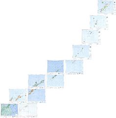
Description: Composite by the uploader of twelve U.S. Army Map Service maps (Series L506, U.S. Army Map Service, 1954-) to show the islands between Hokkaido and Kamchatka (Kuril Islands, etc); original images here; from the Perry–Castañeda Library Map Collection, The University of Texas at Austin. From bottom left to top right: Nemuro (NK 55-1 Nemuro) & Shikotan-Tō (NK 55-2 Shikotan-To) Rausu (NL 55-10 Rausu) & Naibo-Numa (Iturup) (NL 55-11 Naibo-Numa) Shana (Iturup) (NL 55-8 Shana) & Tokotan (Urup) (NL 55-9 Tokotan) Buruton-Jima (NL 56-4 Buroton-Jima) & Yake-Yama (Simushir) (NL 56-5 Yake-Yama) Ketoi-Shima (NL 56-2 Ketoi-Shima) Shasukotan-Jima (NM 56-11 Shasukotan-Jima) Onnekotan-Jima (NM 56-9 Onnekotan-Jima) Paramushiru-To (NM 56-6 Paramushiru-To)
Title: Composite island map, from Series L506, U.S. Army Map Service, 1954-
Credit: http://legacy.lib.utexas.edu/maps/ams/japan/
Author: U.S. Army Map Service (individual maps), uploader (composite)
Usage Terms: Public domain
License: Public domain
Attribution Required?: No
Image usage
The following page links to this image:
