
Image: Constantinople area map

Size of this PNG preview of this SVG file: 800 × 447 pixels. Other resolution: 320 × 179 pixels.
Original image (SVG file, nominally 1,300 × 727 pixels, file size: 1.03 MB)
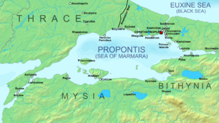
Description: Map of Constantinople (modern Istanbul) and its environs during Byzantine times.
Title: Constantinople area map
Credit: Own work using: Base map: Sea of Marmara map.png, slightly edited. Locations and names of settlements taken from: C. Mango & G. Dagron (eds.), Constantinople and its Hinterland, Variorum 1995, pp. xii-xiii, 110-111, 208
Author: Cplakidas
Usage Terms: Creative Commons Attribution-Share Alike 3.0
License: CC BY-SA 3.0
License Link: https://creativecommons.org/licenses/by-sa/3.0
Attribution Required?: Yes
Image usage
The following 3 pages link to this image:

All content from Kiddle encyclopedia articles (including the article images and facts) can be freely used under Attribution-ShareAlike license, unless stated otherwise.