
Image: Dalmatia

Size of this preview: 768 × 600 pixels. Other resolutions: 308 × 240 pixels | 1,537 × 1,200 pixels.
Original image (1,537 × 1,200 pixels, file size: 49 KB, MIME type: image/png)
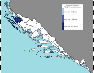
Description: Map of the percentage of Italians in Dalmatia in 1910, as per the Austro-Hungarian census.
Title: Dalmatia
Credit: Own work Basemap of subdivisions comes from page 395 of https://www.jstor.org/stable/41146422?seq=5#metadata_info_tab_content Data for each subdivision is sourced from: https://www.loc.gov/item/a22000873/
Author: Daniel222potato
Usage Terms: Creative Commons Attribution 4.0
License: CC BY 4.0
License Link: https://creativecommons.org/licenses/by/4.0
Attribution Required?: Yes
Image usage
The following 2 pages link to this image:

All content from Kiddle encyclopedia articles (including the article images and facts) can be freely used under Attribution-ShareAlike license, unless stated otherwise.