Image: DeadSeaTransform

Size of this preview: 270 × 600 pixels. Other resolutions: 108 × 240 pixels | 741 × 1,646 pixels.
Original image (741 × 1,646 pixels, file size: 528 KB, MIME type: image/png)
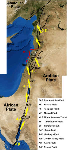
Description: Map of the Dead Sea transform, showing the individual faults. Derived from many published maps including those in the following sources [1], [2], [3], [4], [5]. Yellow arrows and numbers show the direction and amount of movement of the Arabian Plate with respect to the Africa Plate in mm per year, from Gomez et al. 2007. The base map is from screenshots from NASA WorldWind software.
Title: DeadSeaTransform
Credit: Own work
Author: Mikenorton
Usage Terms: Creative Commons Attribution-Share Alike 3.0
License: CC BY-SA 3.0
License Link: https://creativecommons.org/licenses/by-sa/3.0
Attribution Required?: Yes
Image usage
The following page links to this image:

All content from Kiddle encyclopedia articles (including the article images and facts) can be freely used under Attribution-ShareAlike license, unless stated otherwise.
