
Image: Der Aufbau der Republik Deutschösterreich
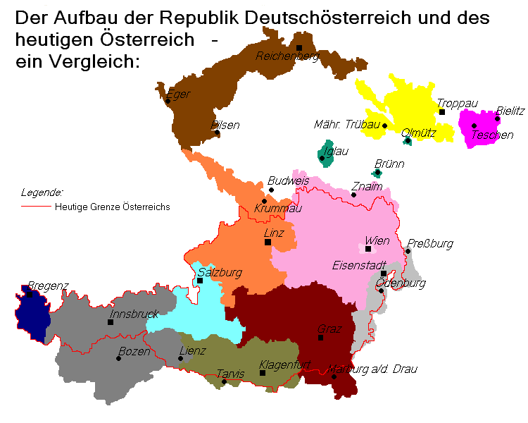
Description: Territory of the proposed Republic of German-Austria in the immediate aftermath of WWI, according to law of the provisional national assembly of German-Austria of 22 November 1918. This included all predominantly German-speaking areas of the Austrian half of the former Austro-Hungarian empire. The border of today's Austria is also indicated for comparison. The areas Vorarlberg and Deutschtirol originally formed a joint province named "Tirol Vorarlberg". The province was however subdivided in 1918, and in 1920 Vorarlberg considered joining Switzerland. The modern Land of Tirol bore officially the name "Deutschtirol", in order to distinguish itself from "Welsch Tirol" (today's Trentino); "Deutschtirol" therefore included the modern South Tirol in Italy. The German-Austrian provinces in detail: Province of Upper Austria: 15.162 km², 1.03 million inhabitant. In 1910, 99.7% of the inhabitants of the former Crown Land of "Austria Beyond the Enns" identified themselves as Germans and 0.2% as Czechs. Province of Lower Austria: 22.048 km², 3.72 million inhabitant. In 1910 95.5% of the inhabitants of the former Crown Land of "Austria Under the Enns" (without the area of German Southen Moravia) identified as Germans and 3.7% as Czechs. 0,1% indicated another nationality. Province of German Bohemia: 14.496 km², 2.23 million inhabitant. In 1919 2.07 million identified themselves as Germans and 116,275 as Czechs. Province of Sudetenland: 6.534 km², 678,880 inhabitants. In 1919 643,804 identified themselves as Germans, 25,028 as Czechs and 5,200 as Poles. Province of Styria: 22.426 km², 1.44 million inhabitant. In 1910, 70.5% of the inhabitants identified themselves as Germans and 29.5% as Slovenes. Province of Salzburg: 7.153 km², 214,997 inhabitants. In 1910, 99.7% of the inhabitants identified themselves as Germans. Province of Carinthia: 10.327 km², 394,735 inhabitants. In 1910, 78.6% of the inhabitants identified themselves as Germans and 21.4% as Slovenes. Province of German Tyrol: 20.047 km², 1.09 million inhabitant. In 1910, 839,000 of the inhabitants identified themselves as Germans, 20,000 as Ladiner and 3,000 as Italians. Province of Vorarlberg: 2.602 km², 145,794 inhabitants. In 1910, 95% of the inhabitants identified themselves as Germans and 5% as Italians. The inclusion areas of German-Austria: Iglau: 374 km², 31,000 inhabitants (1920). Thereof 17,000 Czechs and 14,000 Germans. Bruenn: 70 km², 263,600 inhabitants (1920). Thereof 209,600 Czechs and 54,000 Germans. Olmuetz: 42 km², 66,400 inhabitants (1920). Thereof 51,400 Czechs and 15,000 Germans.Areas officially claimed by German-Austria: German West Hungary East Silesia (joint administration with Poland and Czechoslovakia suggested) Border of the subsequent First Austrian Republic (and modern Austria).
Title: Der Aufbau der Republik Deutschösterreich
Credit: Data sources: "Fibel zur Deutschlandfrage", Vol. 1. Hermann Schroedel Verlag KG Berlin Hanover Darmstadt (1962); "Der Große Brockhaus", Vol. 1-4 (1938); Alexander Sixtus von Reden: "Österreich-Ungarn - Die Donaumonacharchie in historischen Dokumenten" (Verlag Carl Ueberreuter, 1995), Renate Basch Ritter: "Österreich-Ungarn in Wort und Bild«, Menschen und Länder"(Verlag Styria, 1989)
Author: Postmann Michael
Permission: Public domainPublic domainfalsefalse This work has been released into the public domain by its author, Postmann Michael. This applies worldwide. In some countries this may not be legally possible; if so: Postmann Michael grants anyone the right to use this work for any purpose, without any conditions, unless such conditions are required by law.
Usage Terms: Public domain
License: Public domain
Attribution Required?: No
Image usage
The following page links to this image:
