
Image: Description De Mexico et des Lagunes De Ses Environs Gemelli Careri

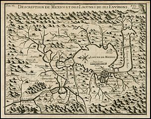
Description: "Rare map of the area around Mexio City, centered on the large Lagune de Mexico and extends to include the surrounding mountains, rivers, towns and villages, reportedly derived from a copy an original native map while Careri was in Mexico. The map is drawn on a partial bird's-eye format, with an imaginary horizon that includes an erupting volcano at upper right. Many villages are located including Pachuca, Tacoma, Atlapilco, Tolodyuca, Tetlapanaloya, and Apazco. Careri's account states that the map is a copy of a map drawn by Charles Siguenza of an original drawn by native Americans. The Mexicans were told to search for a place that would be shown to them by the presence of an eagle standing on a cactus growing out of a rock. This place is Tenochtitlán or the present-day Mexico City. The present map is from an edition of Careri's account published in Paris. The work also appears in Churchill's collection of voyages and travels, published in London, 1704."
Title: Description De Mexico et des Lagunes De Ses Environs Gemelli Careri
Credit: Voyage du Tour du Monde (1719, Paris: French Translation of "Giro Del Mondo").
Author: Gemelli Careri
Usage Terms: Creative Commons Zero, Public Domain Dedication
License: CC0
License Link: http://creativecommons.org/publicdomain/zero/1.0/deed.en
Attribution Required?: No
Image usage
The following page links to this image:
