
Image: Diagram of possible Ur Continent of the (conjectured) Eoarchean Era
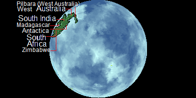
Description: This is a Diagram of the (conjectured) ancient continent of Ur. Ur is a assumed early super continent of earth. It is one of the oldest presumed parcles of land in Earth geological history. Kaapvaal is composed of part of southern Africa Madagascar, Antactica and the Pilbara Region of Western Australia. Geology of these regions indicates that when they were formed they were joined as one continent despite being quite separate today. These regions contain some of the oldest rocks on Earth. Despite being depicted in green, Ur existed prior to the presumed advent of land plants and is assumed it would have been quite barren. This picture depicts the continent as being the only continent at this time, however, this may or may not have been the case it is possible that other land (Now long gone due to geological recycling) existed at this time.
Title: Diagram of possible Ur Continent of the (conjectured) Eoarchean Era
Credit: Own work
Author: D A R C 12345
Usage Terms: Creative Commons Attribution-Share Alike 3.0
License: CC BY-SA 3.0
License Link: https://creativecommons.org/licenses/by-sa/3.0
Attribution Required?: Yes
Image usage
The following page links to this image:

_Eoarchean_Era.png)