
Image: Dorset Map 1834

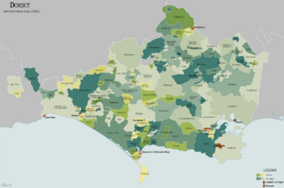
Description: Administrative map of the ancient county of Dorset in 1834. Showing Liberties, Hundreds and Boroughs. Source data on parish boundaries - Kain, R.J.P., and Oliver, R.R. (2001) "Historic parishes of England and Wales: Electronic Map - Gazetteer - Metadata", Colchester: History Data Service. ISBN 0 9540032 0 9. Source data for Boroughs: H.M.S.O. Boundary Commission Report 1832 (courtesy of www.visionofbritain.org). Structure taken from "The Civil Division of the County of Dorset (1833)" by Edward Boswell.
Title: Dorset Map 1834
Credit: Own work
Author: XrysD
Usage Terms: Creative Commons Attribution-Share Alike 3.0
License: CC BY-SA 3.0
License Link: https://creativecommons.org/licenses/by-sa/3.0
Attribution Required?: Yes
Image usage
The following page links to this image:
